Welcome to the Explore! New Mexico blog

Explore! New Mexico searches the state for interesting stories to tell our listeners and readers - and now our blog followers! We are currently producing a series of multi-media podcasts for the Las Cruces Convention and Visitors Bureau about interesting events and places to visit. You can view them at our YouTube channel. Be sure to visit our website where you can get even more ideas about where to travel in the Land of Enchantment.
Showing posts with label southern New Mexico. Show all posts

Monday, January 31, 2011

Doña Ana Poised For Future as Tourist Destination


The wagons churned along the Rio Grande over El Camino Real, advancing only a dozen miles or so each day. Travelers stopped at camps or parajes between Mexico City and Santa Fe. Most of those camps are distant memories, lost in the shifting sands of the desert and the changing course of the river. One of the camps has persisted into the 21st century. We know it as the village of Doña Ana.


On January 15, State Senator Mary Jane Garcia hosted the grand opening of the De La O Visitors Center in Doña Ana, culminating many years’ work of the many descendants who claim the name De La O and creating a focal point for community activities and tourists.


During the festivities, Sen. Garcia asked a show of hands of those who have come from the original De La O family. The senator is cousin to many of the village’s residents. She pointed to one man and asked if he was De La O, to which he concurred. Said the senator, “I’ve known you 20 years and didn’t know you were De La O. Hello, cousin!”


Those attending the grand opening included Las Cruces Mayor Ken Miyagishima, several Las Cruces City Councillors,

representatives of Doña Ana County government, and other dignitaries. Unlike most other similar events, this one had the festive appeal of a family reunion.


Doña Ana dates to the late 17th century. The village, if if could have been called that at the time, was abandoned throughout most of the 18th century. According to Robert Julyan in his book, “The Place Names of New Mexico,” the governor of Chihuahua created the Doña Ana Bend Colony Grant to alleviate crowding in El Paso. But it was not settled until 1843 when Bernabé Montoya led thirty-three settlers to the site. They named their settlement after the semi-legendary Doña Ana, who may have been Ana Robledo who had fled south during the Pueblo Revolt, or Doña Ana María de Córdoba, whose ranch was nearby.


Whoever the name honored, settlers were determined to remain in their village, to farm and to thrive. El Camino Real ran through the heart of the village. It brought not only travelers and trade but also bandidos. It was also prey to

marauding bands of Apache. But it persisted.


Between 1845 and 1850, a decade before the village of Las Cruces was laid out, villagers built a church. It was about a hundred feet long and twenty feet wide. Its adobe walls were three feet thick and its windows high to prevent Indians and bandits from shooting at people sequestered there. Candles in chandeliers and sconces between the Stations of the Cross dimly lit the church. A single clerestory window above the nave close to the apse let in the early morning light to illuminate the altar during Mass.


During the Civil War, De La O opened a saloon about a hundred yards south of the church. Just north of the saloon, Werthheim opened a general store, and north of that was the residence of the Cavello family.


Those buildings have persisted into the present time, but barely. In the late 1970s, the church was about to be condemned and demolished. The adobe buildings down the street had faired better, perhaps because of their boxy single-story construction. The structures seemed destined to melt into history just as old adobe returns to the earth.


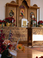
But the community, led by Sen. Garcia, had other plans. Over a decade, Doña Anans, including some at-risk youth, rebuilt the church. They made more than 17,000 adobe bricks to reconstruct one wall which had collapsed and to shore up other parts of the building. Using a design of local artist Jeannie De Lo O Carbajal, who designed the art adorning the I-25 underpass at Highway 320, artisans in Mexico built a new altar patterned on the original which had deteriorated too far to reclaim. They retained the church’s original vigas and corbels and conserved the original French paintings of the fourteen Stations of the Cross. The church today is used for special occasions, including baptisms and marriages.


Then restoration work shifted down Camino Real, which for nearly two decades has been called Cristo Rey, to the old saloon and adjacent buildings.


The L-shaped De La O saloon has been restored with two meeting rooms and the mirror-backed bar, just as it might have looked 150 years ago. Its adobe has been painted white and its walls hung with historical scenes of the village of two centuries ago. Behind the building is a brick placita with fountain, stone planters, and shade trees. The community now has a facility for activities, celebrations, and fiestas.


As funds permit, the Werthheim building will be restored as a mercantile museum and the Cavello house will become the site of a farmers’ market.


For those who think Camino Real is nothing more than two ruts in the desert, come to the village of Doña Ana and see what family can do.


If you’d like to see the restored historic buildings and walk along part of the original royal highway, take Exit 9 off I-25 and turn south on Thorpe Road (NM-320). At the modern Catholic church, Our Lady of Purification, turn left onto Dusty Lane, which bends around the church and becomes Cristo Ray Street.


Thursday, October 28, 2010

Centennial Saturday at Mesilla Valley Bosque State Park


We started our next podcast yesterday when I interviewed Jan Kirwan at the Mesilla Valley Bosque State Park. A most interesting park, Mesilla Valley Bosque is soon to celebrate its second anniversary ... taking time to learn how best to serve the public. There is, of course, the nature story. The park has trails along the river and farther back in a drier part of the flood plain. I hiked both and found tracks of things we commonly see ... lizards, stink bugs, and birds. But then I found tracks of raccoon and javalina. There are beaver living near the park. I didn’t see their tracks but found a tree they had gnawed through. And one of the park rangers has photographed a bobcat. This is a great place for birders to see many of the 213 species that have been identified in the park or migrating through. I was treated to the sight and sound of a high-flying flock of sandhill cranes.

Besides nature, Mesilla Valley Bosque is developing events that teach about and demonstrate our culture. Rangers are centering this “mission” in their Time Travelers program, a living history event developed and run by Dr. Jon Hunner of NMSU. His college students don period costumes and play roles to teach 5th to 12th grade students about local history. It’s not all talk. Participants get to learn how to make tortillas, adobe and how to do the laundry without a washing machine. They learn arts and crafts like beading and are led in Native American dances by members of the Tortugas pueblo.

Saturday, December 4, marks the parks second anniversary and you can take part in Centennial Saturday from 2 to 4 p.m. The Time Travel date is 1912 as participants celebrate New Mexico’s 100th year as a state. Come on out and meet people from a century ago ... even President Teddy Roosevelt.

Mesilla Valley Bosque State Park can be reached by taking Highway 359, Calle del North, in Mesilla ... right across Highway 28 from The Bean. Drive about 2 miles to the Rio Grande and, as soon as you cross the bridge, turn left into the park’s drive. There is a $5 per car park fee.


Posted by Bud Russo

Monday, June 21, 2010


Bud’s Nature Journal: Exploring the geology of the Jornada del Muerto


As desolate as it seems, the Jornada del Muerto is anything but. In fact, it’s surface can be read as if it were a treatise rich in history.


Recently, a group of us went into the Jornada on a rockhound adventure. Many of Doña Ana’s county roads are dirt, and I rode the bumpy roads in the back seat. I recognized Point of Rocks as we headed north. Soon the car came to a stop. We were there, although I have no idea where there is except to say we were deep in the Jornada. There are no forests in the Jornada, unless you want to call some clusters of ocotillo forests. There are no rivers; only dry arroyos. There are no landmarks. It was apparent only the leader of our group knew where she was going. It was also apparent it would be easy to get lost in this desert. I guess that’s one reason it was named journey of death.


So off we went, down a sandy arroyo into a wider one. We were told the solitary cottonwood a hundred yards to our left marked the point where we’d leave the arroyos on our return. That seemed futilely inadequate. We tracked northwest for perhaps a mile, perhaps a mile and a half. We were looking for petrified wood.


Now, if you know anything about the natural history of this area, it was once either the bed of a shallow sea or seashore. There were animals predating dinosaurs ... like dimentrodon, along with a lot of other and often much smaller reptilians. And there were trees ... forests of them.


Today the desert here is sparse. Scattered creosote bush, an odd prickly pear or ocotillo cactus, an even rarer mesquite, and virtually no grass. There’s lots of bare earth, so the search for fossils didn’t take long before one of us shouted, “I found some.” It wasn’t me, and I hurried to see what petrified wood here in the Jornada looked like. I had seen fossils in the Petrified Forest National Monument in Arizona, but I needed a search image to find them in the Jornada.


I examined the lemon-size chunk of rock. Yes, I could see the veins of wood running vertically; the rings arcing horizontally. It was petrified wood alright. It was interesting, but my attention turned to an even more fascinating geological phenomenon just laying there on the ground ... small, dark, round rocks. They were iron and covered the ground like marbles. Some were as small as peas; others the size of golf balls. Some stuck together, like Nipples of Venus or Twinkies. Some had clustered and had the appearance of bubbly crust on a Brown Betty cobbler. It was obvious they had eroded from the sandstone in which many more were still embedded. I began to wonder how they got there and reviewed my meager knowledge of geology.

This is what I concluded.


Having seen Kilauea in Hawai’i, I surmised these balls were spatter from an eruption or lava fountain. Think of it. When 3000-degree molten rock shoots into 80-degree air, it virtually freezes, usually in the form of a ball. The spatter landed in sand. Perhaps it was a beach, much like the more muddy beach where the Paleozoic fossil tracks were made. Perhaps not. Whatever its source, the sand was the landing zone for the balls. More sand covered them and, over eons, the overburden compressed the sand into sandstone. You can see the different strata of sand, especially where a thin, darker layer of some other mineral fell to ground before more sand washed over it.


Then the mountains were born and the sandstone heaved to the surface. Wind, rain, and freezing temperatures have eroded the soft sandstone, leaving the hard iron laying on the surface. I gathered some. I even collected a piece of sandstone with an embedded ball. My schoolteacher sister-in-law will appreciate them.


We had been climbing a long, low ridge and now began to skirt the highest part. On the opposite side of the ridge, I had a chin-dropping experience. There laying on the ground were several, whole petrified logs. I couldn’t determine how long they were since they were partially buried. At least five to six feet were exposed, and they’d been exposed a long time. The rock was cracked and crumbling. You couldn’t collect an entire log, even if you had the machinery to dig and lift it. But here it was, telling a story that predates dinosaurs, a story of the time when there were no mountains, not even a North America. And who knows where these trees were born? Were they temperate like our pine forests are today? Or from some tropical region near the equator? I still find it hard to believe huge pieces of earth’s crust slide over the molten core, changing places and shapes. But here was evidence as plain as the nose on my face, although my nose has chosen to remain where it’s been since birth.

The Jornada is a desert, silent and pensive. It keeps its own counsel but it’s not stingy. It will share its life story with anyone willing to walk through it, willing to observe and listen. And look beyond the human impact on the land, to a time long before there were even humans or even mammals.


The piece of ancient tree I brought home sits on my desk and I marvel at how it was formed and how it became rock. It may be my imagination, but if it had eyes, they’d twinkle; if it had a mouth, there’d be a curious, mischievous smile. It knows so much more than I do, and I long to know what it knows. Maybe I need to journey again into the Jornada, to journey again back in time and read the open pages of its history.